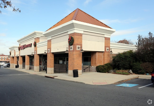
Property Record
2910 Chain Bridge Rd, Oakton, VA 22124
NEARBY LISTINGS FOR SALE OR LEASE
Property Detail
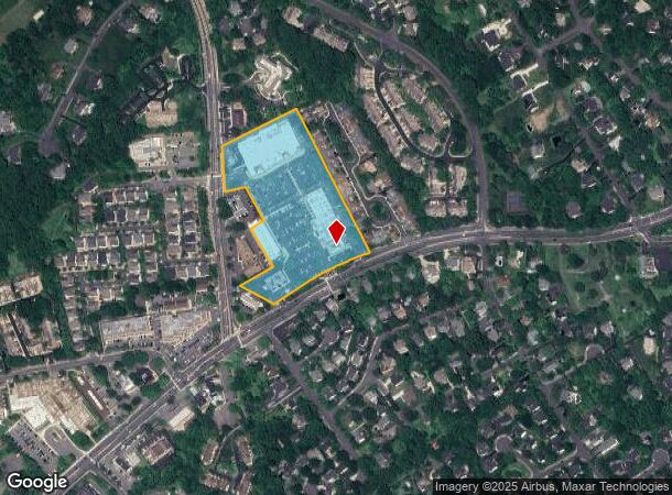
2910 Chain Bridge Rd
Washington-Arlington-Alexandria, DC-VA-MD-WV
Oakton
0472-01-0099
OAKTON 3377 283 289 3377 291
Communitycenter
Fairfax
X
Virginia
51059C0145E
99
2024
10.90 AC
2025
Oakton
461100
Washington, DC
141,002 SF
DEMOGRAPHICS near 2910 Chain Bridge Rd
1 Mile
3 Mile
5 Mile
2024 Total Population
12,687
95,243
271,257
2029 Population
12,368
95,485
269,488
Pop Growth 2024-2029
(2.51%)
+ 0.25%
(0.65%)
Average Age
40
40
39
2024 Total Households
4,723
34,102
100,520
HH Growth 2024-2029
(2.73%)
+ 0.27%
(0.68%)
Median Household Inc
$159,470
$158,595
$148,240
Avg Household Size
2.60
2.70
2.60
2024 Avg HH Vehicles
2.00
2.00
2.00
Median Home Value
$727,074
$758,424
$746,110
Median Year Built
1980
1977
1983
Nearby Places
Map Layers
Map Styles
 Street
 Aerial
- Restaurants
- Banks
- Shops
- Fitness
- Groceries
PUBLIC TRANSPORTATION
COMMUTER RAIL
Burke Centre (Manassas Line - Virginia Railway Express)
DRIVE
WALK
Distance
Burke Centre (Manassas Line - Virginia Railway Express)
16 min
7.1 mi
Rolling Road (Manassas Line - Virginia Railway Express)
DRIVE
WALK
Distance
Rolling Road (Manassas Line - Virginia Railway Express)
18 min
8.6 mi
AIRPORT
Washington Dulles International
DRIVE
WALK
Distance
Washington Dulles International
28 min
14.0 mi
Ronald Reagan Washington Ntl
DRIVE
WALK
Distance
Ronald Reagan Washington Ntl
30 min
20.2 mi
Freight Ports
Port of Baltimore
DRIVE
WALK
Distance
Port of Baltimore
75 min
53.0 mi
Nearby Properties
Address
Land Use
TOTAL SIZE
Lot Size
Zoning
Address
Land Use
TOTAL SIZE
Lot Size
Zoning
1,393,336 SF
43.08 AC
400
Address
Land Use
TOTAL SIZE
Lot Size
Zoning
819,540 SF
8.81 AC
COMMERCIAL
Address
Land Use
TOTAL SIZE
Lot Size
Zoning
561,458 SF
8.30 AC
COMMERCIAL
Address
Land Use
TOTAL SIZE
Lot Size
Zoning
82,818 SF
6.16 AC
PLANNED DE
Address
Land Use
TOTAL SIZE
Lot Size
Zoning
775,934 SF
13.98 AC
312
Address
Land Use
TOTAL SIZE
Lot Size
Zoning
382,776 SF
11.02 AC
400
Address
Land Use
TOTAL SIZE
Lot Size
Zoning
255,553 SF
25.61 AC
RESIDENTIA
Address
Land Use
TOTAL SIZE
Lot Size
Zoning
225,058 SF
596
Address
Land Use
TOTAL SIZE
Lot Size
Zoning
300,730 SF
9.60 AC
400
Address
Land Use
TOTAL SIZE
Lot Size
Zoning
504,528 SF
20.91 AC
220
Address
Land Use
TOTAL SIZE
Lot Size
Zoning
354,464 SF
7.51 AC
400
Address
Land Use
TOTAL SIZE
Lot Size
Zoning
230,346 SF
25.18 AC
460
Address
Land Use
TOTAL SIZE
Lot Size
Zoning
260,278 SF
5.78 AC
400
Address
Land Use
TOTAL SIZE
Lot Size
Zoning
424,763 SF
47.76 AC
SPLIT ZONE
Address
Land Use
TOTAL SIZE
Lot Size
Zoning
315,292 SF
14.98 AC
220
Address
Land Use
TOTAL SIZE
Lot Size
Zoning
500 SF
9.67 AC
180
Address
Land Use
TOTAL SIZE
Lot Size
Zoning
164,186 SF
596
Address
Land Use
TOTAL SIZE
Lot Size
Zoning
443,750 SF
33.08 AC
530
Address
Land Use
TOTAL SIZE
Lot Size
Zoning
180,256 SF
3.33 AC
330
Address
Land Use
TOTAL SIZE
Lot Size
Zoning
353,340 SF
7.89 AC
400
Address
Land Use
TOTAL SIZE
Lot Size
Zoning
114,815 SF
10.43 AC
953
Address
Land Use
TOTAL SIZE
Lot Size
Zoning
341,924 SF
12.78 AC
220
Address
Land Use
TOTAL SIZE
Lot Size
Zoning
500 SF
14.27 AC
110
Address
Land Use
TOTAL SIZE
Lot Size
Zoning
7.53 AC
220
Address
Land Use
TOTAL SIZE
Lot Size
Zoning
120,069 SF
55.63 AC
110
Address
Land Use
TOTAL SIZE
Lot Size
Zoning
59,591 SF
9.25 AC
597
Address
Land Use
TOTAL SIZE
Lot Size
Zoning
185,063 SF
15 AC
460
Address
Land Use
TOTAL SIZE
Lot Size
Zoning
101,332 SF
7.17 AC
COMMERCIAL
Address
Land Use
TOTAL SIZE
Lot Size
Zoning
173,067 SF
10.87 AC
297
The World's #1 Commercial Real Estate Marketplace
Connect with us
© 2025 CoStar Group
The information above has been obtained from sources believed reliable. While we do not doubt its accuracy we have not verified it and make no guarantee, warranty or representation about it. It is your responsibility to independently confirm its accuracy and completeness. Any projections, opinions, assumptions, or estimates used are for example only and do not represent the current or future performance of the property. The value of this transaction to you depends on tax and other factors which should be evaluated by your tax, financial, and legal advisors. You and your advisors should conduct a careful, independent investigation of the property to determine to your satisfaction the suitability of the property for your needs.